
How To Find Your Property On FEMA’s Flood Insurance Rate Maps

What are FEMA flood maps?
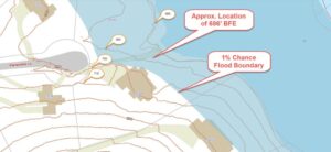
FEMA’s Flood Insurance Rate Maps (FIRMs) or just Flood Maps are provided after a flood risk assessment has been completed or updated for a community.  This study is known as a Flood Insurance Study.  The FIRM gives you the Base Flood Elevations (BFEs) and insurance risk zones in addition to floodplain boundaries.  The FIRM may also show a delineation of the regulatory floodway.

Once the “insurance risk zone”  (commonly referred to as the flood zone) is determined, actuarial rates, based on these risk zones, are then applied for newly constructed, substantially approved, and substantially damaged buildings.  FEMA uses these rates to determine the insurance rate you will pay for flood insurance

FEMA’s Digital Flood Maps

FEMA discontinued the production and distribution of paper flood maps in 2009 as part of its Digital Vision Initiative. This affected all the Flood Maps, boundary information, and study reports. However, clients can still view the products for free through their website or buy them in digital format.

To view these flood maps online, go to FEMA’s Map Service Center and key in your address (hi-lited area shown here) search for your home.  This will prompt you to then select the map that covers your area.  The Flood Maps are somewhat cumbersome to use online. It is best to go through the tutorial on the bottom right of the address search page for an easier and more effective use of the GIS map.

author avatar
Surveyor

More Posts

Home sale pending with property documents and a mortgage survey being reviewed before closing
land surveying
Surveyor

How a Mortgage Survey Supports a Smooth Home Closing

Buying a home means signing a lot of paperwork on closing day. One of those documents may be a mortgage survey. If you have never seen one, you might not think about it until a question comes up. Maybe a fence looks like it sits in the wrong spot. Maybe

Read More »
Surveyor completing a boundary survey along a residential fence line in Wisconsin
boundary surveying
Surveyor

Planning a Fence Project With a Boundary Survey

A new fence sounds like a weekend project. Pick a line, set the posts, hang the panels. But the spot you choose matters more than the panels you buy. Put a fence a foot over the real property line and you can end up moving it later, or working things

Read More »
Septic system installation following a perc test in Wisconsin
land surveying
Surveyor

Why Your Septic Permit Needs a Perc Test First

If you plan to build on a rural lot, the septic system often sets the limits. People call the first step a perc test. In Wisconsin the real work is a bit wider than that one phrase. Before the state or a county approves a private septic system, someone has

Read More »
A survey crew uses a drone to map farmland in Wisconsin
drone surveying
Surveyor

What It Really Costs to Map Land With a Drone

There is no set price for mapping land with a drone. No statewide flat rate exists, and no honest quote starts with acreage alone. What you pay depends on the map you ask for, how accurate it has to be, how the field work gets set up, whether a licensed

Read More »
Commercial property site plan being reviewed as part of an ALTA survey, showing building layout, parking areas, and property boundaries
alta survey
Surveyor

What Lenders Look for in an ALTA Survey

A commercial loan file usually includes an ALTA survey. Before funds move, the lender’s team checks that survey against the title work and the loan terms. Below is what that review tends to focus on, and why each piece matters to the people signing off on the loan. A Survey

Read More »
Survey equipment used to prepare an elevation certificate for flood insurance on a Wisconsin property
flood damage
Surveyor

Why Your Flood Insurance Premium Might Be Wrong

If you own property, your flood insurance bill is based on a set of facts about your land and your building. When those facts are wrong, your premium is wrong too. A lot of homeowners pay more than they should because their file has old data in it. Some pay

Read More »